
Serving the Vermont Champlain Valley Area for 45 Years
Main SectionsFront Page SportsValley VitalsIt's in the StarsStarwiseArchivesLinksAbout The VoiceContact Us |
Telling Tales Of Otter Creek
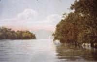
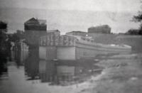
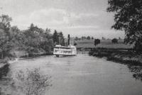
Monday September 2, 2013 By Cookie Steponaitis Otter Creek winds its way north for a hundred miles from Mount Tabor and empties into Lake Champlain in Ferrisburgh, Vermont. It is not only Vermont’s longest river but one of the most critical for telling the story of settlement, movement and revolution in the region. Life along its banks dates back to the original Abenaki names Onegilwizbo meaning Otter River and Bikogtegw or Crooked River. Otter Creek has artifact proof of people living, fishing and traveling its waters from as early as 1000 B.C. and links to other tributaries creating a network of highways that early people used to live near and transport goods throughout the Green Mountains and the Connecticut, Battenkill and Hudson Rivers to the ocean. One must look at the stories of the Native Americans, French traders, explorers and other European settlers to learn the story of this lengthy but often lackadaisically flowing river and the changing nature of the land in order to understand the true impact of the waters of Otter Creek. While many credit the arrival of Samuel de Champlain and the French in 1609 as a turning point in the story of the region, Otter Creek was in fact already part of an established Abenaki population center and for a time the two groups coexisted peacefully in the area. During the late 17th and 18th centuries hostilities between the two groups increased and the most strategic means of transport, whether it was for troops, prisoners, supplies or carrying out a campaign was the waters of Otter Creek. As Indian trails evolved into planned roads, the famed Military Road was constructed and connected forts to other areas in the state including Rutland, Clarendon, Pittsford and Sudbury winding around the many miles of the Otter Creek. By July 31, 1760 eight hundred men had worked through an intense winter to complete the road that allowed not only the military but settlers to move into the interior of New England. Although little of this road survives some towns have integrated stretches of it into their modern roadways. The Military Road provided a means for people to settle within the region and resulted in an increased need for cleared land and grazing land for livestock. Otter Creek was the highway on which goods and people moved and created growing communities from the hewn and sawed logs and goods transported by water. A variety of industries are intermingled into the story of the Otter Creek that included mills, iron, charcoal, marble, limestone and lime products and the ever changing phases of Vermont agriculture including the era of Merino Sheep beginning in 1816 and reaching its peak close to the Civil War. At one time Addison County produced more wool than any other place in the United States. Woolen mills, some located in the Middlebury area sprung up by 1850 and utilized the canals and accessible Otter Creek to provide the region with their services. Land was quickly cleared and grazing pastures were added to address the needs of large herds of sheep. Steamship business increased in conjunction with the dominance of sheep farming and sailed up and down the Otter Creek and Lake Champlain with cargo and passengers. Dairy cows replaced sheep as the predominant agricultural venture and by 1920 the picturesque images of cows grazing on the hillsides and fields of wheat, corn and hay became associated with Vermont continuing to this day. Otter Creek is bordered by the Green Mountains and Taconic Mountains Ranges and is a highway to the past with strong ties to the present and future. It has been impacted by the pattern of settlement and life in this region which continues to this day but also serves as a silent but ever present participant in the story of life in the region from the earliest days of people to present times. It brings people to new awareness and locations accessible only by boat. Currently the habitat includes a documented wetland with a variety of birds attracted to the region including over one hundred species, reptiles and fish. Whether spoken in French, La Rivière aux Loutres or by its English name Otter Creek, it continues to offer not only recreation but is of environmental importance and shows Vermonters a way to study the changing history of the region and the changing landscape.
|
AdvertisementsSearch our Archives |

 Printer Friendly
Agricultural Weather Forecast:

© 2006-18 The Valley Voice • 656 Exchange St., Middlebury, VT 05753 • 802-388-6366 • 802-388-6368 (fax)
Valleywides: [email protected] • Classifieds: [email protected] • Info: [email protected]